
Ringing in the new year is always a time for reflection and prognostication. That's no different at JVM Studio, but we'll keep things short and sweet.
Read MoreHow should cities respond to Uber and Lyft? The Philadelphia Inquirer asks JVM Studio to weigh in
Researchers from the University of California-Davis Institute of Transportation Studies just completed one of the most comprehensive studies to date on how people use ride-hailing services like Uber and Lyft. The Philadelphia Inquirer asked four local experts - Chris Puchalsky from the City of Philadelphia, Erick Guerra from the University of Pennsylvania, Brett Fusco from the Delaware Vally Regional Planning Commission, and JVM Studio's Jonas Maciunas - what the study's findings mean for Philadelphia.
Read MoreFeatured in PlanPhilly
Last year, PlanPhilly asked people why Philadelphia needs safer streets. Here's what we told them.
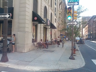
Measuring The Street: Cars in the Italian Market
Parking is essential to retail, right? Especially in off-center commercial corridors with a reputation for attracting tourists and folks coming back to "the old neighborhood," right? Philadelphia's iconic Italian Market is on its way to establishing a business improvement district, giving the district the capacity to make some collective decisions. Janette Sadik-Khan, New York City's transformative former Transportation Commissioner under Michael Bloomberg says that measuring the street for transportation, economic, and social impacts of design changes is critical to good decision-making. I thought I'd test the thesis of the importance of parking and car access by doing some simple counts on a busy Saturday. What I found was pretty surprising.
Read MoreEast Market Street Requires a ReDesign
East Market Street was designed in 1984 and no longer serves the needs of our city or the preferences of the market. Not only does it create an unsafe pedestrian environment, constraining the economic potential of the district, but it provides no enduring pleasure. Philadelphia’s “main street” should be a joy to stroll along. Amid the ongoing surge of private investment, the time has come to take a hard look at the priorities of the public realm on East Market Street.
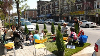
Read More(Accidental) Success for OpenStreets PHL
Open Streets, the national effort to open up streets to pedestrians, is gaining steam. Millennials love it; it makes children happy, and it even seems to give old folks an extra spring in their step. But what about entrepreneurs and mom+pop retailers trying to make a buck? Might such restriction of vehicular traffic and parking dissuade their customers, squeeze their margins, and be more of a headache than it's worth? We got a chance to find out, and the results were really exciting.
Read MoreTransect Talk: Trails and Parkland
Philadelphia has a beautiful history and network of parks and trails. After a long hike a little while ago, it dawned on me that parks and trails, just like buildings and streets, range from urban to rural, and that "getting it right" in those various contexts makes a huge difference. In other words, beaux-arts fountains in the woods make about as little sense as building a raised ranch with a picket fence next to City Hall. I'm going to use this post to show how a great long hike through Philadelphia parkland exposes you to a nearly perfect transition through the trail transect.
Read MoreHalloween: another reason row houses are totally awesome
Halloween might be the holiday made best by walkable urban places. Christmas and its caroling has its charms and may give All Hallows Eve a run for its money, but who can argue the awesomeness of trick-or-treating with a new door to knock on every 15-to-100 feet? I can't imagine being a kid in the exurbs. Being driven around to each and every daily activity is bad enough, but imagine needing to be driven house to house for trick-or-treating? Fortunately, the town I grew up in was an inner ring suburb well built for halloween. Even so, I've been blown away by the spooky atmosphere created in my Philadelphia neighborhood. People really go all out, and the proximity to the sidewalk of each Halloween-costumed house really heightens the experience.
Read MoreSEPTA Expansion: First, How Did We Get Here?
Back in last September, SEPTA was facing the very real prospect of drastic cuts in service because of decades of deferred maintenance resulting from a funding structure that gives it far less juice than other comparable systems. I called it the unnecessary doomsday scenario, but boy, what a doomsday scenario it would have been.
Since then, however, the passage of Act 89 by the Pennsylvania legislature, in the words of the General Manager, "is a watershed moment for transportation in the Commonwealth. For the very first time, transportation agencies have a predictable, bondable, and inflation-indexed funding solution to to repair failing bridges, highways, and transit systems across the state. Already, credit rating agencies foresee a positive economic outlook. The entire state stands to benefit from this landmark piece of legislation.
"For SEPTA, Act 89 provides an opportunity to play catch up on a growing $5 billion backlog of capital replacement needs. The funding will allow SEPTA to advance a wide-ranging program of mission critical projects, such as bridge replacements, substation overhauls, and and the customer experience."
What does all that mean? Basically, in addition to improved customer service, other management practices, and the long-awaited deployment of new payment technology, there will be a lot going on behind the scenes (and under the bridges) to get the existing system up to snuff and still functioning ten years from now. In other words, $5B for critical things that will, in many ways, go unnoticed and, unfortunately, might not be broadly appreciated.
One exception is going to be the replacement of the 1980 trolley fleet with new, low-floor boarding, higher capacity vehicles. THIS will be a transformative investment, especially for West Philadelphia, where what basically operates as a system of buses that can't get out of the way of an obstruction in the street, will be transformed into a modernized system that functions more like the light rail we're always finding ourselves jealous of in far-flung places like Portland and Houston. Faster boarding, greater vehicle capacity, and stations that extend the sidewalk out to the track will be like a brand new rapid transit system for West Philadelphia. This a big deal, and with a little luck (though limited confidence, given the recent track record), SEPTA will avoid the siren song of advertising/sponsorship, and develop/keep a strong visual brand for the newly improved system... but more on that another time.
But this all still begs the question: what's next? SEPTA has a predictable revenue stream in place for the first time ever. It's prudent to make these state-of-good repair and service improvements first, but before long, they will have been made, and we'll still have this revenue stream in place. We shouldn't be proposing any major service expansions until the system is restored, but once it is, the legislature could easily cut that funding stream if additional transportation needs of the region aren't being planned to be met.
There will be plenty of time to speculate about service expansions - new subways, regional rail re-extension to places like Reading and Lancaster, trolley restoration, rapid transit on the Boulevard, and more. But right now, I thought it'd be good to illustrate the building of the Center City passenger rail network over the years. After all, it was built incrementally, not over night, and any future changes should stand on the shoulders of the evolution of the system before them. These maps are based on a my synthesis of historic maps of the city and some cursory, non-academic research (wikipedia and some rail fan sites) on operators and stations. Other than the ones that still exist today, I avoided showing trolleys (which is a whole 'nother discussion of disinvestment, repeated city after city). This is not meant to be an exhaustive review of each and every detail, and I'm sure there are corrections to make, but the intent is to show the general trajectory we have been on, in order to better consider where we'll go next.

In the earliest days, the Pennsylvania Railroad ran trains all the way down Market Street to the Delaware River by way of Dock Street. But after we realized you really shouldn't be running steam locomotives down you Main Street, here is what we got. The Reading Railroad, naturally, terminated at Reading Terminal and the Pennsylvania Railroad terminated at the grand Broad Street Station, both built in 1893. It's worth noting that until 30th Street Station was built, and Broad Street was demolished, intercity trains (think today's Amtrak service) would pull all the way into Broad Street, across the street from city hall, and then back out to continue their journey.
There was no subway or 30th Street Station, just a smaller station at 32nd Street. The Baltimore and Ohio ran a line along the Schuylkill, with a pretty beautiful station at Chestnut Street, and service to New York City that didn't require the Broad Street back-in-and-out. West Philadelphia trolleys converged on Market Street and ran all the way to Front Street, where they looped around. The Pennsylvania Railroad also ran a New Jersey based division that terminated at Camden (these trains went north and to the shore). Ferry service between the cities abounded. Remember, unlike today's Monolithic SEPTA (with the exception of PATCO and NJTransit buses) this is in the era when services were run by lots of different operators. I won't be getting into the details of which is which, generally, but it's worth remembering.
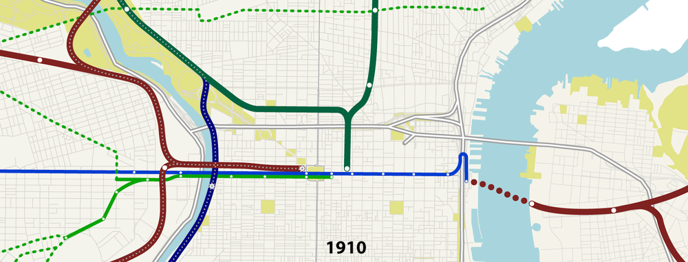 As you can imagine, trolleys on Market street got more and more crowded. Long story short, the trolleys were put in a tunnel, terminated at City Hall (just like today) and a company was created, authorized by the City, to build a Market Street subway in 1907. Originally, this it was elevated west of 22nd Street and terminated at the Delaware, connecting passengers to the Ferries from Camden. It was called the Ferry Line, and would soon extend to South Street, where there was another ferry terminal. It's also worth noting that in the days before the Broad Street subway, there were more stops on the inner section of the Reading line, including at Fairmount and Girard Avenues.

The 1920s and 30s witnessed huge expansion of the system. Let's look at what those expansions were.

With the construction of highways sweeping the nation, you wouldn't think there would be much happening on the railroad front. In fact, retrenchment was the spirit of the era.

Despite Ed Bacon's fantasies of miniature trolleys shuttling people back and forth on Chestnut Street, the 1960s were still all about highway construction. However, this period also witnessed the implosion of the private passenger railroads. Everything got really confusing and entities like SEPTA were created to manage the chaos. In 1968, PATCO began running one the three lines PB had recommended into Center City by way of the Ben Franklin Bridge. Though SEPTA didn't own track and rolling stock until 1983, by 1966, both the Reading and Pennsylvania Railroads operated commuter lines under contract to the Authority. This set up the situation where the SEPTA regional rail system was bifurcated between trains terminating at Suburban and those terminating at Reading. Enter: Vukan Vuchic.
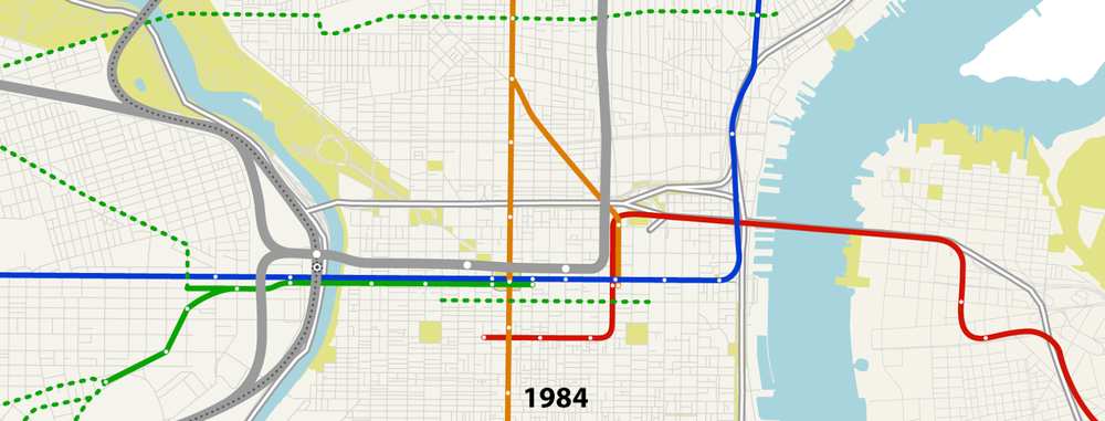 The construction of I-95 on the Delaware River shifted the El from Front Street into the highway alignment we know today, and replaced a Fairmount station with today's Spring Garden Station. Ed Bacon's vision for Chestnut Street was tranformed into The Transitway in 1976, though it would be incrementally dismantled. Most importantly, the Center City Commuter Connection created a tunnel between Suburban Station and Reading Terminal, renamed Market East (and now, Jefferson Station). This connection allowed for trains that used to terminate at each station to pass through Center City to become another route on the other side. Though SEPTA has been criticized for not sufficiently taking advantage of the connectivity the tunnel allows, as I've discussed before, doubling the transit access to Market West is indelibly linked to its growth as an office district.
 Since the Tunnel's completion in 1984, however, little has changed in the system, with the exception of the creation of the River Line between Camden and Trenton on the other side of the Delaware. In Philadelphia, the broader retrenchment trend of the second half of the 20th century continued with the gradual elimination of the Chestnut Street Transitway and the 1992 replacement of Route 23, 15, and 57 trolleys with buses (though the 15 on Girard Avenue would be re-instated in the next decade).
It's been a long time since any major network changes have happened in the central Philadelphia transit system, mostly because SEPTA has been doing its best just to minimize the bleeding. But now that the Authority is in a strong financial position for the foreseeable future and is making lots of state-of-good-repair improvements (and majorly re-investing in the existing trolley system), the question should be asked: what's next?
There will be plenty of time to thinking and discuss that, but a good place to start is to look at where we've been.
Since then, however, the passage of Act 89 by the Pennsylvania legislature, in the words of the General Manager, "is a watershed moment for transportation in the Commonwealth. For the very first time, transportation agencies have a predictable, bondable, and inflation-indexed funding solution to to repair failing bridges, highways, and transit systems across the state. Already, credit rating agencies foresee a positive economic outlook. The entire state stands to benefit from this landmark piece of legislation.
"For SEPTA, Act 89 provides an opportunity to play catch up on a growing $5 billion backlog of capital replacement needs. The funding will allow SEPTA to advance a wide-ranging program of mission critical projects, such as bridge replacements, substation overhauls, and and the customer experience."
What does all that mean? Basically, in addition to improved customer service, other management practices, and the long-awaited deployment of new payment technology, there will be a lot going on behind the scenes (and under the bridges) to get the existing system up to snuff and still functioning ten years from now. In other words, $5B for critical things that will, in many ways, go unnoticed and, unfortunately, might not be broadly appreciated.
One exception is going to be the replacement of the 1980 trolley fleet with new, low-floor boarding, higher capacity vehicles. THIS will be a transformative investment, especially for West Philadelphia, where what basically operates as a system of buses that can't get out of the way of an obstruction in the street, will be transformed into a modernized system that functions more like the light rail we're always finding ourselves jealous of in far-flung places like Portland and Houston. Faster boarding, greater vehicle capacity, and stations that extend the sidewalk out to the track will be like a brand new rapid transit system for West Philadelphia. This a big deal, and with a little luck (though limited confidence, given the recent track record), SEPTA will avoid the siren song of advertising/sponsorship, and develop/keep a strong visual brand for the newly improved system... but more on that another time.
But this all still begs the question: what's next? SEPTA has a predictable revenue stream in place for the first time ever. It's prudent to make these state-of-good repair and service improvements first, but before long, they will have been made, and we'll still have this revenue stream in place. We shouldn't be proposing any major service expansions until the system is restored, but once it is, the legislature could easily cut that funding stream if additional transportation needs of the region aren't being planned to be met.
There will be plenty of time to speculate about service expansions - new subways, regional rail re-extension to places like Reading and Lancaster, trolley restoration, rapid transit on the Boulevard, and more. But right now, I thought it'd be good to illustrate the building of the Center City passenger rail network over the years. After all, it was built incrementally, not over night, and any future changes should stand on the shoulders of the evolution of the system before them. These maps are based on a my synthesis of historic maps of the city and some cursory, non-academic research (wikipedia and some rail fan sites) on operators and stations. Other than the ones that still exist today, I avoided showing trolleys (which is a whole 'nother discussion of disinvestment, repeated city after city). This is not meant to be an exhaustive review of each and every detail, and I'm sure there are corrections to make, but the intent is to show the general trajectory we have been on, in order to better consider where we'll go next.
The Early System
In the earliest days, the Pennsylvania Railroad ran trains all the way down Market Street to the Delaware River by way of Dock Street. But after we realized you really shouldn't be running steam locomotives down you Main Street, here is what we got. The Reading Railroad, naturally, terminated at Reading Terminal and the Pennsylvania Railroad terminated at the grand Broad Street Station, both built in 1893. It's worth noting that until 30th Street Station was built, and Broad Street was demolished, intercity trains (think today's Amtrak service) would pull all the way into Broad Street, across the street from city hall, and then back out to continue their journey.
There was no subway or 30th Street Station, just a smaller station at 32nd Street. The Baltimore and Ohio ran a line along the Schuylkill, with a pretty beautiful station at Chestnut Street, and service to New York City that didn't require the Broad Street back-in-and-out. West Philadelphia trolleys converged on Market Street and ran all the way to Front Street, where they looped around. The Pennsylvania Railroad also ran a New Jersey based division that terminated at Camden (these trains went north and to the shore). Ferry service between the cities abounded. Remember, unlike today's Monolithic SEPTA (with the exception of PATCO and NJTransit buses) this is in the era when services were run by lots of different operators. I won't be getting into the details of which is which, generally, but it's worth remembering.
Subways on Market Street
Rapid Expansion
The 1920s and 30s witnessed huge expansion of the system. Let's look at what those expansions were.
- The Frankford line opened in 1922. For a brief period, the Market Street subway would have two branches - the Ferry and Frankford lines.
- The Broad Street line opened in 1928, but terminated at Lombard/South.
- In 1932, the Broad Ridge Spur began service from the north to 8th and Market Streets.
- The Pennsylvania Railroad opened Suburban Station in 1930 and 30th Street Station in 1933, intending to send intercity trains through 30th Street and suburban ones underground (I do love the station's double-meaning) through Suburban. The Broad Street Station remained, however, presumably because money had run out to tear it down, and continued to serve a portion of the city's intercity service until it was torn down in 1952.
- in 1936 (yes, i know, a year after the image is labeled), the Delaware River Joint Commission (predecessor to PATCO) began running the "Bridge Line" on the newly constructed Ben Franklin Bridge. This would spell trouble for the ferries. Originally, this line only ran between Broadway in Camden and 8th and Market Streets in Philadelphia. Connections to the Pennsylvania Railroad were required for any journeys east of Camden from Philadelphia.
Mid-Century Retrenchment
With the construction of highways sweeping the nation, you wouldn't think there would be much happening on the railroad front. In fact, retrenchment was the spirit of the era.
- In 1952, the Pennsylvania Railroad demolished Broad Street Station, formalizing the condition we know today (with one major exception) where regional trains run to suburban, and intercity trains run to 30th Street.
- The B&O Station at 24th and Chestnut was closed in 1958.
- After a some temporary closure, the Ferry Line of the Market Street subway was closed in 1953. This eventually makes way for Delaware Avenue and I-95.
- There is a general demise of regular ferry service across the Delaware,
- The Broad Street line had been extended south of Lombard/South to Snyder Avenue in 1938.
- Most notably, the Delaware River Port Authority was created in 1951, taking over the Bridge Line. Hired by the Authority to develop a rapid transit plan for South Jersey, Parsons Brinckerhoff recommended building a tunnel to serve three lines. Though the tunnel was deemed to expensive and eastern improvements wouldn't happen yet, the line was extended in Philadelphia to the Locusts Street terminus we know today.
More Stagnation, but stabilization in a Chaotic Era
Despite Ed Bacon's fantasies of miniature trolleys shuttling people back and forth on Chestnut Street, the 1960s were still all about highway construction. However, this period also witnessed the implosion of the private passenger railroads. Everything got really confusing and entities like SEPTA were created to manage the chaos. In 1968, PATCO began running one the three lines PB had recommended into Center City by way of the Ben Franklin Bridge. Though SEPTA didn't own track and rolling stock until 1983, by 1966, both the Reading and Pennsylvania Railroads operated commuter lines under contract to the Authority. This set up the situation where the SEPTA regional rail system was bifurcated between trains terminating at Suburban and those terminating at Reading. Enter: Vukan Vuchic.
A Breakthrough Moment
Today - The Lull Before the What?
It's been a long time since any major network changes have happened in the central Philadelphia transit system, mostly because SEPTA has been doing its best just to minimize the bleeding. But now that the Authority is in a strong financial position for the foreseeable future and is making lots of state-of-good-repair improvements (and majorly re-investing in the existing trolley system), the question should be asked: what's next?
There will be plenty of time to thinking and discuss that, but a good place to start is to look at where we've been.
When a Bike Lane is More than a Bike Lane
This post originally appeared as a Helen Ubinas column in the Philadelphia Daily News. Supplemental italicized text and graphics in this post are intended to lend some color commentary and further clarity to the issues presented in Helen's original text.
 |
| Philly PD, in the bike lane and ON the sidewalk. I have dozens of such photos. |
Parking in a bike lane endangers people, plain and simple, even if you're doing it for "just a minute." Each time a cyclist is obstructed by a parked car, they swerve unexpectedly into traffic, posing a risk to themselves and the drivers behind and beside them. Not everybody realizes this, and to a degree, that's understandable. But I've found the City of Philadelphia's own police department to be a frequent blocker bike lines - and no, not when responding to emergencies, but mostly stopping at a convenience store for a coke, lottery tickets, and a hangout with fellow officers... all on time paid by the taxpayers dime.
MY MISSION? To stake out the blocked bike lane outside the 7-Eleven near the corner of 22nd and Lombard streets.
I eyed the stoop at a closed flower shop across the street, perfect for unobstructed surveillance.
I downloaded a counting app to keep track of all the bikers riding by.
I was about to grab a Big Gulp and settle in, when the first culprit pulled into the bike lane and parked.
A woman, outwardly healthy looking, stepped out of a shiny Mercedes with a handicapped-parking placard dangling from the mirror and sashayed into the store. Moments later, two officers in a police cruiser pulled up behind her and headed inside.
The Big Gulp would have to wait.
A few weeks earlier I'd met Jonas Maciunas, one of Philadelphia's increasing number of cyclists. (A new report by the Bicycle Coalition of Greater Philadelphia found that between 2005 and 2013, bicycle commuting across the Schuylkill rose 260 percent.) Maciunas was irked at how often the bike lane at 22nd and Lombard near his home was blocked by inconsiderate, lawbreaking drivers. He'd taken to posting his frustrations on Twitter. But no amount of public shaming stopped civilians, cabbies and cops from parking in the lane who then forced bicyclists to go around the vehicles and into traffic.
Check it out for myself, Maciunas said. I'd see.
He was right. On the night I visited, it was a free-for-all.
No matter that it was clearly a bike lane, with a white bicycle symbol. No matter that it was marked with a "No Stopping" sign. (Oddly, if a bike lane is marked with a "No Parking" sign, cars are allowed to park for 20 minutes.) No matter that cops who were supposed to be enforcing the law were flouting it right along with other traffic scofflaws.
Any delusion I had that the cops who parked behind the Mercedes were going to give the driver a ticket or a good talking to was smashed when the officers emerged from the 7-Eleven with a large coffee, a Big Gulp and even bigger chips on their shoulders. Big surprise there.
When I asked them why they were parked in a bike lane, they had lots of excuses. There's nowhere else to park, one cop said. Their sergeant said it was OK. Another officer, who said he was making a security check, said if I wanted them to be sticklers about the law (isn't that kind of the point of being a cop?) then cyclists would also have to be cited for blowing through traffic lights. I'm OK with that. So is the Bicycle Coalition, as long as vigorous enforcement goes both ways. Here's the thing: the officer's logic, paraphrased, "because some cyclists break rules, we should respect the safety of none of them," is nearly identical "because I saw a black guy rob somebody once, we should stop and frisk all of them." The latter is insane (though that doesn't stop somebody from trying), but somehow the former is considered a reasonable position by an officer of law enforcement.
I can already hear many of you: With all the problems in Philly, why focus on one bike lane? Two things - 1) enforcement of behavior by private citizens is one challenge; 2) getting one city department (police) to respect the actions of another (streets) really shouldn't be. I don't think you'll ever have the general public respect rules if their own police force doesn't.
You can disagree whether we should have bike lanes or not, and where they should be. That's a reasonable position (and I happen to come down on one side of it) that reasonable people can have a debate about (which we'll get to in a moment), but once you have them, I think its imperative to respect and enforce them, not actively try to subvert them. After all, we don't think of speed limits as mere guidelines and the building code isn't just a recommendation.
[Also], because sometimes a bike lane is more than just a bike lane.
Just ask Maciunas, 30, who says disregarding the safety of bicyclists in lanes throughout the city speaks volumes about Philadelphia's culture, priorities and future economic development.
"I think if Philadelphia wants to underestimate the mobility preferences of a generation that's going to be 75 percent of the workforce in 10 years, then we can do that," he said. "But don't be surprised when people choose to go elsewhere. Our narrow streets won't carry many more cars, so at the end of the day, growth will require prioritizing other modes." Typical Philadelphia streets are 26 feet wide and the workforce of the future is less and less interested in driving. As a matter of geometry and market preference, growth requires a re-prioritization of how we allocate those 26 feet.
 |
| Protected bike lanes are safer for all users. (photo: US Dept. of Transportation) |
Maciunas is an urban strategist with the RBA Group. He thinks big picture like this, which is how Philly has to keep thinking if it wants to keep competing with other cities that are attracting and keeping residents. Make no mistake, people are choosing between cities and companies are following them. Philadelphia has great bones and has done great things, but we've got to keep our edge.
While we should care about even one blocked bike lane that's putting bicyclists in danger, there's actually even more at stake here: We either want to make the city more accessible and attractive to residents who want a walkable and bikeable place to live, or we don't.
We're either serious about enforcing all our laws or we aren't.
We either respect each other's space - even if it's a bike lane that may mean we have to look elsewhere for parking - or we don't.
But we can't say we prioritize law and order and economic development and smart growth of our city and then shrug it off if it's inconvenient or we're just jonesing for a Big Gulp.
Sgt. Eric Gripp said the Police Department is aware of the issue and has made it clear to officers that parking in bike lanes is unacceptable and won't be tolerated. Philadelphia Parking Authority deputy executive director Richard Dickson, who said curb space is an ongoing balancing act, said the PPA will continue to monitor #unblockbikelanes, the hashtag cyclists use to report blocked bike lanes. You've been warned.
But don't do it just because you want to avoid a ticket.
"We have been blessed with a really wonderful grid of narrow streets, walkable neighborhoods and a robust transit system," Maciunas said. "It's why people choose Philadelphia. But other cities, whether it's Denver, Austin, or D.C., are learning from the model that we set. They're trying to eat our lunch by restoring transit lines and building protected bike lanes. This isn't just a 'feel-good' thing; this is about keeping our competitive edge."
So stay out of the bike lanes, people.
 |
| Keep the tickets coming! |
To the great credit of the police department, I've noticed a dramatic decrease in the amount of 7-11 parking since Helen's article ran in August. Not only that, but I recently noticed tickets issued to vans parked in the 13th Street bike lane. A nearby Parking Authority enforcement officer, who commented on how contractors often feel entitled to park there, said it wasn't him, but probably the Police that issued them. Hats off for taking a step in the right direction. Let's hope they keep it up.
Think tank’s urban jobs agenda misguided: cities must be empowered, not wards of the state
This post originally appeared as an op-ed in the Hartford Business Journal by your correspondent and David Panagore.
The Connecticut Policy Institute (CPI), founded by Republican gubernatorial candidate Tom Foley, issued a series of white papers earlier this year about economic development.
With the election for the state's top spot heating up and Foley running neck and neck with Gov. Dannel P. Malloy, it's a good time to assess some of the economic development initiatives and thinking from the contender's camp.
By our review, we suspect the results might not be something small government types like Foley can get behind. In fact, when not proposing policies that are already in place, CPI's recommendations are a brazen play to extend and further centralize state power. We were struck by the anti-local and over simplified analysis.
How simplistic? The data used by CPI to chart "urban jobs" and their decline was actually regional, implying towns like Fairfield or Simsbury are equally suffering from Bridgeport and Hartford's "urban" malaise. What this data actually suggests is that the state has a metropolitan jobs problem and that the suburban growth (sometimes at the expense of cities), and urban decline, actually mask this even more significant challenge.
CPI's analysis also oversimplifies the similarities between the state's major cities and makes the same recommendations across the board as though each city struggles for the same reasons. Though each community would benefit from more business activity and jobs, they face different challenges, requiring different approaches for economic development. For example, Bridgeport has about 146,000 residents but only 40,000 jobs. Hartford has only 125,000 residents yet supports 115,000 jobs.
CPI's one-size-fits-all urban centers analysis also assumes permitting and regulations for suburban greenfield development and urban development should be indistinguishable. They view local permitting as a bureaucratic impediment, rather than a complex series of demands driven by the history, density, and conflicts more inherent in urban than greenfield development.
Asserting that local governments "can't get it right," CPI recommends expanding state power to usurp municipal development programs and regulations, smacking of outdated central planning. This recommendation is confrontational, good for big developers, and bad for communities. However, while creating zones where developers could be exempt from local regulations in favor of state standards is a bad idea, streamlining permitting approval is a good one. An alternative to the CPI proposal would be to competitively provide cities with resources to overhaul their regulatory infrastructure, which Hartford has already begun.
Tax breaks are often traded for jobs, either new jobs or retaining existing jobs as a means of driving development. CPI recommends vastly expanding enterprise zone areas, clarifying the rules, and requiring job growth as the measuring stick. While the potential for good is there, more work needs to be done, otherwise the state will be imposing tax cuts, not on a deal-by-deal basis but across the board, fundamentally undercutting local revenue.
CPI has it right that transportation is key to revitalization, but makes expansion of Tweed or Sikorsky airports their only infrastructure recommendation for urban jobs growth. Expansion of the state's transportation infrastructure is critical, and that includes all of the airports, rail and port options. The state needs to determine how its cities and Bradley International Airport fit into the North Atlantic region and, through rail connections, strengthen that relationship with the Boston-Washington rail corridor.
Among the last of CPI's recommendations is for a statewide small business incubator program. This initiative takes a page from Gov. Dannel P. Malloy's playbook, but instead of taking it a step forward, takes it one step back. Incubators are out of date. Created with the best intentions, they have become government-subsidized places for small business to stay on life support in a state of "zombie-preneurship."
The Malloy administration has developed CT Next, a comprehensive set of accelerators, support services, one-stop shops, fostering the existing network. CPI is on the right track, but needs to kick Malloy's plan up a notch, not take one step back. Finally, CPI promotes placemaking in urban development, and endorses improving Bushnell Park, the New Haven Green, and the Bridgeport waterfront. We welcome CPI aboard for seeing the light on that recommendation.
Connecticut's urban jobs crisis is deeply enmeshed in our fiscal crisis. CPI correctly identifies the vicious cycle of urban disinvestment in which deindustrialization, tax base erosion, and higher taxes to maintain services compound each other. Here's a radical proposal to break that cycle: Rather than creating a new tax, or racing to the bottom to cut existing ones, let selected cities keep a portion of the state income tax generated within their boundaries. This would more accurately reflect urban economic activity, ease the property tax burden, allow for improved municipal services and infrastructure, and take the state out of the annual subsidy business.
Our cities should not be wards of the state. Ensuring that they are not, and fostering job growth, requires engagement and empowerment, not doubling down on state control.
David Panagore is the former chief operating officer of the city of Hartford. He writes an occasional column for the Hartford Business Journal. Jonas Maciunas is an urban planning consultant with the RBA Group and previously served as complete streets coordinator for the city of Hartford.
Make Transit a Downtown Priority and Get the Details Right
This post originally appeared as an op-ed in the Hartford Courant. Supplemental italicized text and graphics in this post are intended to lend further clarity to the issues presented in the original text. Your correspondent previously served as the City's Complete Streets Coordinator and has been involved in several of the projects discussed.
As recent research at the University of Connecticut indicates, too much surface parking is bad for downtowns. Citing Hartford as an example, the study finds that large swaths of blacktop drive down the value of surrounding property, making development less likely, which in turn begets more parking. In spite of being the highest concentration of jobs in the entire State, the conclusion of this unfortunate spiral is a place with plenty of parking but not much to do after you park.
A big part of the solution is improved transit, and with fewer than 10 percent of downtown Hartford employees currently using transit, there’s room for improvement.
The current bus system, while imperfect, is fairly robust, and in 2015, CTfastrak will create a fast and reliable car-free option from New Britain to Hartford, serving points in between and beyond. In 2016, the state Department of Transportation’s implementation of the New Haven Hartford Springfield rail program will triple service to Union Station. This is a big deal.
However, just as the best retailers know that offering good products and being near foot traffic aren’t always enough, maximizing transit ridership is about more than building the infrastructure. It’s about enhancing the convenience of the service so current passengers get the most out of it and newcomers want to try it.
If they miss this point, the new Hartford bus and rail services will sell themselves short.
The greater Hartford Transit District, as part of the City's Intermodal Triangle Project, is making pedestrian-oriented improvements to Union Place. The station's Great Hall will become much more accessible and a new transit center will be added next to the main hall for newly routed buses from east-of the-river. The result will be a much-improved approach to the City's intercity travel hub.
In anticipation of other forthcoming improvements, the Hartford Business improvement District, together with the City and the Transit District, has added new signage to Union Station, providing orientation and helping to better position the Station toward Asylum Street.
The DOT is planning to spend $2.6 million to build an elevated platform at Union Station to increase boarding speed and make for a more pleasant modern travel experience. This is a good idea. However, the current design requires passengers to walk nearly 200 additional feet north on a narrow walkway from the waiting area stairs. It also misses the opportunity to utilize the station’s historic great hall as a welcoming entry to the City. Instead, trains will continue to be accessed through the busy bus station known as the "Transportation Center."
Yale's Vincent Scully once said of the demolition and subsequent reconstruction of New York's Penn Station "One entered the city like a god; one scuttles in now like a rat." You might not exactly scuttle in like a rat to Hartford today, but creating a more dignified arrival to the Capital City can do wonders in changing perception.
At the end of the day, this looks like a bare-bones effort to meet the minimum standards of the American's with Disabilities Act (ADA), not to create a first-rate travel experience for all users or anticipate exceeded ridership projections. However, the department is unwilling to consider bolder alternatives because of possible track relocation related to the transformative reconstruction of I-84. According to Commissioner Redeker, those changes are almost 20 years away.

Introduction
 |
| Acres of parking in the shadow of tens of thousands of jobs and the State Capitol |
A big part of the solution is improved transit, and with fewer than 10 percent of downtown Hartford employees currently using transit, there’s room for improvement.
The current bus system, while imperfect, is fairly robust, and in 2015, CTfastrak will create a fast and reliable car-free option from New Britain to Hartford, serving points in between and beyond. In 2016, the state Department of Transportation’s implementation of the New Haven Hartford Springfield rail program will triple service to Union Station. This is a big deal.
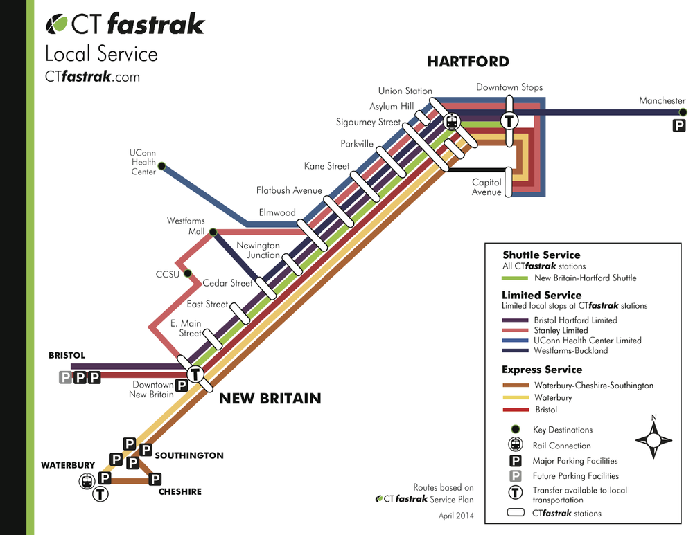 |
| CTfastrak local service map (www.ctfastrak.com) |
 |
| New Haven-Hartford-Springfield service map (www.nhhsrail.com) |
However, just as the best retailers know that offering good products and being near foot traffic aren’t always enough, maximizing transit ridership is about more than building the infrastructure. It’s about enhancing the convenience of the service so current passengers get the most out of it and newcomers want to try it.
If they miss this point, the new Hartford bus and rail services will sell themselves short.
Union Station
 |
| Streetscape improvements designed for Union Place (Tai Soo Kim Architects). Construction beginning in Spring 2014 |
In anticipation of other forthcoming improvements, the Hartford Business improvement District, together with the City and the Transit District, has added new signage to Union Station, providing orientation and helping to better position the Station toward Asylum Street.
 |
| Asylum Street for St. Patrick's Day Parade (ctnow.com) |
 |
| Union Station Transportation Center, next to the Great Hall |
 |
| Union Station's Great Hall begs to be put back to use as a transportation hub |
Union Station used to have more than the single track it has today. ConnDOT's planned platform improvements are focused on the central platform adjacent to the existing track. The platform between the Great Hall and the former second track will go untouched. According to the Department, a second track is not necessary to operate the soon-to-be increased service and will not be added until the whole viaduct structure is reconstructed.
 |
| A ConnDOT rendering of the elevated platform (right) illustrating how it is accessed |
 |
| A section of the platform improvements by the Connecticut Department of Transportation |
| An elevation of the platform improvements by the Connecticut Department of Transportation |
The other problem with the current design is one of ridership and infrastructure capacity. The current platform design, because of restrictions on stopping on a curve and the location of the existing platforms' glass headhouses, is limited to letting about three railroad cars meet the platform. Even today, Amtrak's Vermonter and Northeast Regional services (see this previous post for a breakdown of existing service at Union Station) operate longer trains than that. If ridership on the forthcoming New Haven-Hartford-Springfield commuter service exceeds projections, (which is not an unusual occurrence), the department will have to delay the addition of new cars and or bear the expense of rebuilding the platform to accommodate them. Both of these could be avoided by building in a little extra capacity at the start.
At the end of the day, this looks like a bare-bones effort to meet the minimum standards of the American's with Disabilities Act (ADA), not to create a first-rate travel experience for all users or anticipate exceeded ridership projections. However, the department is unwilling to consider bolder alternatives because of possible track relocation related to the transformative reconstruction of I-84. According to Commissioner Redeker, those changes are almost 20 years away.
") |
| Big-Time changes to the face of Downtown Hartford if I-84 is rebuilt and the railroad is shifted (credit - Tri-State Transportation Campaign) |
Providing a sub-par rail experience at the system’s busiest station for a generation because of uncertain billion-dollar highway improvements demonstrates a serious lack of commitment to growing ridership on the new service. Half the country away, on the other hand, the city of Saint Paul just refurbished their historic Union Depot in anticipation of the restoration of Amtrak service. These are the types of places that private investment chooses to then flow. Victoria says that Hartford is trying, and it looks like Saint Paul is trying harder, but there's no reason changes can't be made.
Two blocks east, the governor has announced funding for over $30 million of hospitality-oriented improvements to the XL Center “to get eight to ten years out of it, frankly.” Union Station merits similar consideration.
Two blocks east, the governor has announced funding for over $30 million of hospitality-oriented improvements to the XL Center “to get eight to ten years out of it, frankly.” Union Station merits similar consideration.
Here's an alternative. If, instead, an elevated platform were built over the abandoned and removed track area, it could be nearly as long as you want it to be, be significantly easier to access, and be seamlessly connected to the Great Hall. The Great Hall, even without a major overhaul of any kind, could then be the primary station for rail passengers, allowing more space to be dedicated to intercity bus (Greyhound etc) passengers in the Transportation Center below. This would certainly take more than the currently dedicated $2.6M and might even take an additional year or two to get done, but the result would be several years of high quality station experience until such time when the whole railroad is shifted as part of the I-84 project.
 |
| A section of an alternative platform improvement |
| A section of an alternative platform improvement |
 |
| A basic 3-D model, showing the Great Hall (right), existing station-adjacent platform (right-center), multiple stairs and ramps (left-center), and an elevated platform over the un-used track area. |
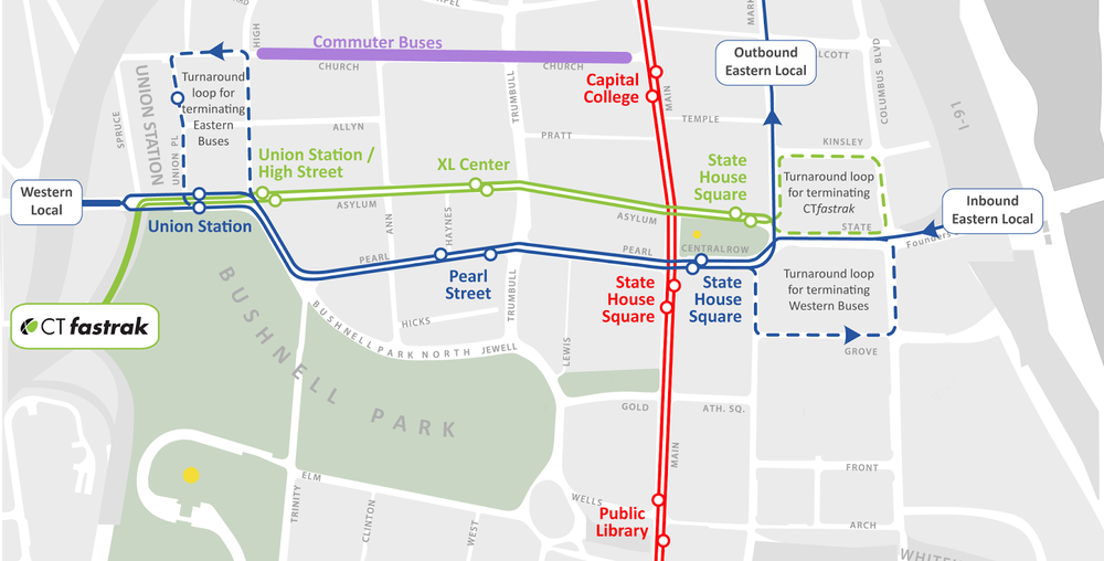
CTfastrak and Local Bus Service
Meanwhile, today’s local bus system notoriously congests Main Street. It also leaves east-of-the-river routes stranded on Market Street and doesn’t give buses from the west direct access to the XL Center or office buildings around Trumbull Street. Furthermore, the system is very difficult to understand as an unfamiliar rider because inbound and outbound stops, particularly on western routes, are often not across the street from one another, and the system as a whole lacks directional signage and iconography informing you how the service operates — none of these conditions are good for downtown or make for a system that successfully attracts new passengers.
The City was awarded a federal grant (the TIGER-Funded Intermodal Triangle) two years ago to improve the pedestrian experience from Union Station to Main Street and make changes to bus routing to improve service and maximize the impact of CTfastrak. In 2012, city, state and regional transportation officials determined that reopening the historic “isle of safety” at the Old State House and utilizing Pearl and Asylum Streets could create direct, convenient downtown access and ease pressure on Main Street.
The 2012 plan sought to alleviate the current system shortcomings by having eastern and western routes pass through the downtown, instead of terminating in the most congested areas. This way, recovery time for western routes could happen on Grove Street instead of in front of the Travelers and eastern routes could get all the way to Union Station instead of ending at Market Street. This allowed for a decongestion of buses from Main Street without hampering the service at all. The plan hinged on turning Asylum Street into a two-way street, with only buses permitted in the newly-opened eastbound direction.
Whether at Union Station or on downtown streets, improved transit is one piece of the puzzle to make Hartford more livable, accessible and development-oriented. But transit will only flourish if the city and state work with the community to make it a priority and realize a vision in which parking is no longer the best use of prime downtown land. We still have that opportunity; let’s get it right.
 |
| Transit Routing Today in Downtown Hartford |
The current challenges of the bus system are rooted in the fact that all services terminate at the core of the downtown instead of going through. For example, northbound buses must stop in front of the the Wadsworth Atheneum and Old State House because western buses are using the Travelers block of Main Street to recover any extra time (which is why they seem to "sit" for a long time) and turn back westward on Asylum Street.
The City was awarded a federal grant (the TIGER-Funded Intermodal Triangle) two years ago to improve the pedestrian experience from Union Station to Main Street and make changes to bus routing to improve service and maximize the impact of CTfastrak. In 2012, city, state and regional transportation officials determined that reopening the historic “isle of safety” at the Old State House and utilizing Pearl and Asylum Streets could create direct, convenient downtown access and ease pressure on Main Street.
 |
| Transit Routing as Planned by the City of Hartford, Capital Region Council of Governments, and Connecticut Department of Transportation in 2012 |
 |
| Bus lane on Chestnut St. in Philly |
However, concerns raised by local retailers, primarily about the proposed bus-only lane, seem to have led DOT officials to throw up their hands and abandon the agreement on routing.
As a result, Farmington Avenue buses from the west will become less convenient to the heart of Downtown, Pearl Street will continue to be used as a parking lot by commuter buses, CTfastrak won’t directly serve the XL Center, and Main Street will have even more buses than today, with the addition of western routes terminate on the block just north of Asylum Street. With CTfastrak expected to replant the stops of today's western routes, one must conclude that northbound routes will continue to stop in front of the Atheneum and Old State House.
As a result, Farmington Avenue buses from the west will become less convenient to the heart of Downtown, Pearl Street will continue to be used as a parking lot by commuter buses, CTfastrak won’t directly serve the XL Center, and Main Street will have even more buses than today, with the addition of western routes terminate on the block just north of Asylum Street. With CTfastrak expected to replant the stops of today's western routes, one must conclude that northbound routes will continue to stop in front of the Atheneum and Old State House.
Neither CTfastrak nor western routes appear to deliver people directly to destinations like the XL Center, City Place, or State House Square without meandering for a while first. But Asylum, the City's central east-west street, use used for a quick and convenient exit from downtown. The plan below risks perpetuating an observation frequently made about Hartford - it's confusing to get to your destination, but really easy to leave.
A city aspiring to be transit-oriented needs to make destinations convenient to get to and not let its transportation undermine its placemaking efforts.
A city aspiring to be transit-oriented needs to make destinations convenient to get to and not let its transportation undermine its placemaking efforts.
 |
| Transit Routing as Inferred to be Planned by the Connecticut Department of Transportation |
By disengaging when controversy arose and following the apparent path of least resistance, we could exacerbate current problems and undermine the new service. The 2012 plan may not have been the right one, but stakeholders need to come together for a better solution than this.
Stakeholders should work together to make sense of the many interrelated implications of transit routing choices as a reflection of their values. That being said, below is one alternative among many permutations for responding to the concerns of retailers and property owners in a way that does not worsen existing conditions or undercut the goals of the new, potentially transformative CTfastrak service.
 |
| An Alternative Transit Routing Among Many |
The Department's current plan is based on the premise that commuter buses, which operate only during rush-hour, must occupy Pearl Street (which, as residents have noted, can be a real headache because of the time they often wait to get moving), pushing local service to other streets. If, instead, local all-day service were prioritized, the Pearl Street alignment of eastern and western routes could be realized and Main Street could achieve its goal of being less of a "bus depot."
With regard to CTfastrak, it can be much more effective if it doesn't run the long loop of today's western routes. If, instead, it traveled inbound and outbound on Spruce, Church, and Trumbull Streets, it would hit major destinations and be much easier to understand by having stops on both sides of each street.
The challenge is determining how to turn CTfastrak around in a way that doesn't recreate current problems. This is where part of the 2012 plan could be resurrected by making the eastern block of Asylum Street a two-way street (with only transit permitted eastbound) and opening a single lane of upper State Street (instead of two-way). This way, the terminating stop of CTfastrak could be at the core of the city at the Old State House (without impacting on the commercial property on the north side). Furthermore, unlike the western blocks of Asylum Street, the implementing a bus-only lane on the eastern blocks wouldn't involve a bus stop requires the elimination of no on-street parking spaces. As an added bonus, but for the rush hour period when they'd have to accommodate suburban commuter buses, the eastern and central blocks of Asylum Street (Trumbull to High) could have parking on both sides of the street... Even more than today. And that's a good thing for retail.
Conclusion
Whether at Union Station or on downtown streets, improved transit is one piece of the puzzle to make Hartford more livable, accessible and development-oriented. But transit will only flourish if the city and state work with the community to make it a priority and realize a vision in which parking is no longer the best use of prime downtown land. We still have that opportunity; let’s get it right.
Economic Development - How Philadelphia Snagged Comcast without Giving Away the Farm
Comcast Innovation and Technology Center - This is the year's big real estate development news in Philadelphia.
Comcast and Liberty Property Trust announced the plan to construct a $1.2B skyscraper at 19th and Arch in Center City, designed by Lord Norman Foster. There will be much discussion of the design and the economic impact of such a development, but there's another important story here - Philadelphia has just caught a big - no, gigantic - fish without wading into the sordid waters of corporate relocation/retention incentive one-upsmanship, which so many cities and states seem unable to resist. But this development is neither an accident, nor to the credit of the will if a single administration or development official; rather, it's the product of at least three decades of strategic choices and turning the tide in the City of Brotherly Love (and Sisterly Affection).
 |
| The tall building is the original Comcast Center; the taller building is the Innovation & Technology Center (courtesy of Comcast) |
 |
| Rendering of Jackson Labs in Farmington (www.governor.ct.gov) |
A Patient, Strategic Approach. On the other hand, Philadelphia seems to have taken a different approach. Comcast's decision to double down on and grow in the city was the result of neither tax giveaways nor direct subsidy. So what's the deal?
As noted above, it's the result of at least three decades of strategic decision-making (and probably owing credit to Ed Bacon before that), which I'd boil it down to three categories, run collaboratively but by different organizations - transit, placemaking, and center city living - which combine to make Philadelphia a place where people want to be, and can do high-quality, dense development.
Transit. - In 1984, SEPTA connected Suburban Station with the Market East Station with a tunnel so that rather serving as terminals for the routes of the former Pennsylvania and Reading Railroads, the lines were through-routed and passengers with access to each basically doubled. For anybody unfamiliar with Philly, imagine the impact of Boston's North Station routes having access to South station and vise versa, or New York's Penn Station and Grand Central Terminal being connected. The result was a building boom in Market West in the 80s, laying the groundwork for the Comcast projects. In fact, the Innovation and Technology Center will have a single level of underground parking - maybe room fewer than 100 cars... for a building housing 4000 people. Without this and continued investment in SEPTA, Comcast would need to build structured parking at 20K-40K per space (and that adds up awfully quick) or find cheap, flat land in the exurbs. But the beauty of the Center City Commuter Tunnel is that it's not a public investment that serves one project; it can be used again and again by anybody. In short, it's a front-loaded public/private partnership.
Placemaking. Philadelphia has a long history of great civic art, starting with William Penn's original five squares to the Parisian Ben Franklin Parkway. But by the 70s and 80s, some of the luster had worn off and the Philly had earned a reputation as a pretty grimy place - enter Paul Levy and the Center City District. Their work started with spit and polish to make Center City clean and safe, which is critical to just about any successful downtown. But before long, the District collaborated with Mayor Rendell and launched an arts initiative on South Broad Street, which involved the clustering of several institutions and beautifying the street so as to capitalize on the City's assets and create a world-class destination. Inga Saffron may say this program is now in need of a little reinvention, but it was a critical step in changing the perception of the city and what it had to offer. The combined result has been streets that are fun during special events, and every day in between. Add this to a growing residential population, and Center City retail is making a full comeback, further energizing the streets, and this is the kind of place Richard Florida's creative class want to be.
Center City Living. Speaking of growing residential population, Center City Philadelphia's rose by 16% between 2000 and 2010 to over 57,000 people, leading to the first overall increase in the city's total population in over sixty years. And it's no longer a secret that a thriving residential population is key to any downtown revival, and that the option of downtown housing is appealing to many working for companies that cities around the country want to attract. But this population rise wasn't an accident either. In 1997, the City of Philadelphia boldly enacted a 10-year tax abatement program, triggering genuine boom in downtown residence. Though controversial, that's a tax incentive almost anybody can take advantage of, and by most accounts, it has really paid off.
Philadelphia has always been a walkable city with unbeatable historical assets but those things wouldn't have led to the development of the Comcast Center without improvements to transit, placemaking, and center city living. This trio is certainly not the whole nor the end of the story, but it is a case study in strategic moves made to encourage growth. Each of these improvements require a city's investment in itself, and none of them come cheap. They also don't provide the instant gratification of job creation, but such is the nature of patience.
The difference between this sort of strategy for recruitment of companies and the jobs that come with them, and one built on specific financial incentives in each "economic development" deal, is that they benefit everybody and can be taken advantage of again and again, in a virtuous cycle. If I were so bold, I might even call that sort of economic development "sustainable."
Other cities, take note.
 |
| (courtesy of planphilly.com) |
 |
| Philadelphia International Festival of the Arts (courtesy of phillyfoodfinders) |
Center City Living. Speaking of growing residential population, Center City Philadelphia's rose by 16% between 2000 and 2010 to over 57,000 people, leading to the first overall increase in the city's total population in over sixty years. And it's no longer a secret that a thriving residential population is key to any downtown revival, and that the option of downtown housing is appealing to many working for companies that cities around the country want to attract. But this population rise wasn't an accident either. In 1997, the City of Philadelphia boldly enacted a 10-year tax abatement program, triggering genuine boom in downtown residence. Though controversial, that's a tax incentive almost anybody can take advantage of, and by most accounts, it has really paid off.
Philadelphia has always been a walkable city with unbeatable historical assets but those things wouldn't have led to the development of the Comcast Center without improvements to transit, placemaking, and center city living. This trio is certainly not the whole nor the end of the story, but it is a case study in strategic moves made to encourage growth. Each of these improvements require a city's investment in itself, and none of them come cheap. They also don't provide the instant gratification of job creation, but such is the nature of patience.
The difference between this sort of strategy for recruitment of companies and the jobs that come with them, and one built on specific financial incentives in each "economic development" deal, is that they benefit everybody and can be taken advantage of again and again, in a virtuous cycle. If I were so bold, I might even call that sort of economic development "sustainable."
Other cities, take note.
The Unnecessary SEPTA Doomsday Scenario
As Paul Nussbaum recently reported for the Philadelphia Inquirer, SEPTA, which provides commuter rail, subway, a few versions of light rail, and bus service for Philadelphia and its surrounding counties, has presented a doomsday scenario if the Commonwealth chooses not to provide substantial cash infusions for capital improvements over the next several years.

Some will suggest that transit is a drain on tax money that should operate more like a business (or that it should even be private business), despite not holding roads and highways to this same standard. But let's looks at SEPTA's operating and capital circumstances.
Here's the amazing thing: based on data from the National Transit Database, SEPTA (2011) has the third highest operating recover ratio (revenues from fares per operating costs) of any commuter rail service in the country - 56.7% - all while while offering service remarkably cheaply the average ticket costs only $3.60... meaning each ticket's operating subsidy is only $2.70. You don't get much lower than that, so suffice it to say that on the business-efficiency argument, SEPTA scores mighty high marks. One would think that such high performance would ought to be rewarded, not forced into doomsday cuts.
That's the operating side. But on the other capital side, SEPTA is basically funded by farebox returns and the general fund of the state, for which it is always competing with every other worthy and unworthy interest in government. How can you expect a capital intensive activity like transportation to operate "like a business," without having any real capacity for capital investment? The result is that the agency is doomed to fail through deferred maintenance.
Some more enlightened regions have come up with alternatives. New York's MTA uses bridge/tunnel tolls to to help pay for transit (which then mitigates congestion by giving people non-bridge/tunnel options). Denver and Los Angeles have what amount to special assessment districts that fund transit. Even Houston, in that lone star land of fiscal conservatives, has 1% sales tax dedicated to transit. There are many ways to skin this cat and give a transit agency borrowing capacity it needs to perform critical maintenance and service expansions.
At the moment, it's important for the legislature (pushed by the City and counties with potential service cuts) to pony for capital improvements. But until Pennsylvania comes up with a means of providing SEPTA with capital funding that doesn't depend on the Commonwealths general fund budget, these doomsday scenarios will inch toward reality, and we can forget about any kind of future service expansions.
ThirdPlace WorkSpace: Special Edition - Park(ing) Day Preview and Recommendations
Park(ing) Day comes but once a year, and this year it seems to be bigger and better organized than ever. You can even post to a website that will map each such intervention around the world. Pretty cool. It's a great idea - our cities have been overrun by cars and parking, so let's reclaim some of that space for the humans as ThirdPlace - and has gained real traction. At the time of this post, here in Philadelphia, there are already over forty participants officially signed up. That makes for a great visual impact for helping people visualize a different future. But allow me to present a possible next frontier.
Typically, Park(ing) Day focuses on converting on-street spaces to park spaces. In Philly, this has even inspired the Mayor's Office of Transportation and Utilities to develop a Parklet Program, going beyond Park(ing) day, which helps businesses or neighborhood groups do such conversions on a more permanent basis.
Focusing on better uses for on-street parking works really great in densely built-up downtowns or neighborhoods, where you begin to question if on-street parking is really still the best use of the space. I find that it works especially well as a way of providing outdoor dining for restaurants (providing a sense of already half-being in the restaurant when you're walking down the sidewalk without encroaching much on the sidewalk and inspiring the killjoy ire of Stu Bykofsky).
But what about cities, towns, and neighborhoods in which on-street parking might not yet represent the worst use of land because that superlative is still held by off-street surface parking lots? This now famous map of Detroit and research by Norman Garrick and Chris McCahill suggest that there are are plenty of places in which the use of buildable lots for parking is worse for the urban environment than on-street parking.
Parking can be important, especially for retail, so maybe a prudent approach, in places that aren't fully built out, would be to focus Park(ing) day activity, not just on on-street spaces, but strategically problematic surface parking lots.
Find the lot that you really think should be a building, rent the corner or edge spaces for the day, and set up a lemonade stand (even if you give it away for free in order to avoid the ire of the relevant city department) or something as a means of simulating the commerce that should be taking place there and helping others visualize it.
In Portland (Oregon, this time, though it pains me to admit), the foodcart vendors that we all know and love are begining to more permanently occupy edge spaces of parking lots and other unbuilt properties. This demonstrates an incremental approach to development and improvement of the public realm that doesn't depend on big, overnight change, which can be so hard to come by.
So... the pictures below show opposite corners of the same block... which do you prefer? Until the owner decides to build or sell, how can this be improved? In downtowns and neighborhoods that aren't fully built out, I think these are the questions needing to be asked when thinking about Park(ing) Day now and in years to come.

 |
| Park(ing) Day example from StreetsBlog |
 |
| Philly Parklet in Chinatown (from MOTU) |
 |
| From Data Driven Detroit |
Parking can be important, especially for retail, so maybe a prudent approach, in places that aren't fully built out, would be to focus Park(ing) day activity, not just on on-street spaces, but strategically problematic surface parking lots.
Find the lot that you really think should be a building, rent the corner or edge spaces for the day, and set up a lemonade stand (even if you give it away for free in order to avoid the ire of the relevant city department) or something as a means of simulating the commerce that should be taking place there and helping others visualize it.
In Portland (Oregon, this time, though it pains me to admit), the foodcart vendors that we all know and love are begining to more permanently occupy edge spaces of parking lots and other unbuilt properties. This demonstrates an incremental approach to development and improvement of the public realm that doesn't depend on big, overnight change, which can be so hard to come by.
 |
| from planningpool.com |
 |
| from eatingmywaythruportland.com |
ThirdPlace WorkSpace Thursdays: Ultimo Coffee Bar
Ultimo was ranked best coffee shop in America (take that, Seattle and New York) - though I think that's the 15th and Mifflin original, not the Graduate Hospital edition I'm reviewing here, but who's really keeping score? - so it's no wonder that I'm a fan. But now that I've been here a few times, I'm realizing the subtle things that also make Ultimo a great place to get some work done, in addition to having a great cup of coffee.
 It's a small space (probably 15 feet deep and 45 feet wide), so it stays intimate, which is always good. table-wise, they've picked a table and stuck with it the whole way - square and comfortable for one person with a laptop or two people without computers. Being on the corner, the shop has a lot of outdoor exposure to work with, which they've maximized by having glass sliding doors across the whole thing (which I've not acdtually seen open, but they make for great natural light). Outdoor seating also exists on the other side of those doors, which is nice. The look inside is simple and natural - a fair amount of wood paneling and elegantly hung single light bulbs. Tunes playing over the speakers are always pretty good - anything from Carla Thomas and Eddie Floyd to The Clash and The Smiths.
 Food and beverage wise, you really can't go wrong. The coffee is flavorful, wonderfully prepared, and never bitter, and the milk comes straight from Lancaster, they way it should always be. Bagels, croissants, etc are good, and they carry sandwiches pre-packaged by Federal Street's own American Sardine Bar.
Philadelphia seems to have a bunch of good cafes with a few locations. I'm definitely going to have to check out the original Ultimo now. Stay tuned.
www.ultimocoffee.com
22nd & Catherine Streets, Graduate Hospital
Table Space – two-seaters, ideal for laptop or a two-person meeting
Philadelphia seems to have a bunch of good cafes with a few locations. I'm definitely going to have to check out the original Ultimo now. Stay tuned.
www.ultimocoffee.com
22nd & Catherine Streets, Graduate Hospital
Table Space – two-seaters, ideal for laptop or a two-person meeting
Wi-Fi – strong and readily accessible
Natural Light – abundant, by way of a wall of full height windows
Atmosphere – cool and relaxed
Bicycle Parking – two racks and a couple street signs
Coffee – $2.45
Third places in a city or town are those that are neither home, work, nor shopping… they are the informal places in between, the public living rooms where we gather or go to be alone in a crowd… and there’s good argument that a culture of solid third places (Parisian café culture is so good as to become cliché) is a driver and indicator of community vitality. They can also be great workspaces for those of us not wanting to work from home, not yet being ready to pay for “real” commercial space, looking to get out of the office, or have a more informal meeting. There’s etiquette (called buying things and not being a slob with your belongings) to working in a café, but doing so can be good for you and the proprietor alike. In this blog, I’ll take you on a reviewed tour of some of Philadelphia’s ThirdPlace WorkSpace (trademark pending) opportunities. I hope you join me.
Naked Bike Ride... Effective Tactical Urbanism or a Robespierre for a Bicycle Revolution?
As I've posted about before, Philadelphia cycling culture, especially in Center City, is strong. As the chicken-egg dance goes, public infrastructure to support that culture is incrementally improving. I sold my car almost five years ago and my bicycle is my primary non-foot means of getting around, so suffice it to say I'm an advocate. But over the weekend, I came to the quick conclusion that a Naked Bike Ride doesn't really advance my cause at this point.
On Sunday afternoon, we were riding down to the grocery store and couldn't figure out why there seemed to be so many more cars on the road than normal for the time/day, and why so many of the drivers were noticeably more aggressive/annoyed by our presence (honking, tailgating, cutting off... that sort of thing, despite our polite riding. Upon arriving at South Street, it suddenly became clear... the entire street was occupied by several blocks of naked and almost-naked cyclists. The event, according to its website, is intended to promote cycling advocacy, raise awareness about fuel consumption, promote positive body image, and promote economic sustainability. As a somebody trying to live those ideals as a part of normal life, I couldn't help but find myself mostly just annoyed by the whole thing.
Now don't get me wrong, this sort of an event can be very important. Actual manifestations and demonstrations of the change you want to see in the world can be very effective means of advocacy, opinion-shaping, and coalition building. It's for exactly this reason that when I was in Hartford, the City and its various civic partners quickly put together winter ice-skating in the park and a summer-fall festival of arts and innovation, despite the fact that major capital improvements to the park and its surroundings were still a few years away, at least. It's the same reason I suspect the Philadelphia Department of Recreation is beginning to heavily program Eakins Oval on the Ben Franklin Parkway (and if not, then the City should really look at re-calibrating this auto-centric piece of transport/park infrastructure). Back in Hartford, Bike/Walk CT and Real Artways (the former being a bit more stodgy/formal, and the latter being a bit more carefree) both orchestrate their own yearly rides to promote cycling in a city in which driving is decidedly still king. These events are successful because they bring new people into the fold, build excitement for the movement, and even bring a little agitation to the status quo.
However, not all tactics remain appropriate at all times. At the risk of being too hyperbolic, part of the reason the French Revolution of 1789 imploded back into dictatorship was that after its initial success based on the ideals of the Enlightenment, rather than broadening the appeal and building coalitions for democratic governance, Robespierre persecuted all those not sufficiently revolutionary for him and the Jacobins. I would submit that, while at one point necessary, certainly fun for those who participate, and entertaining for some (but certainly not all) who see, today's Naked Bike Ride (in a city where cycling is become less an exception and more a normal way of life) is a celebration, not a meaningful advocacy tool. That's fine, even if annoying to drivers and some other cyclists, but don't conflate a celebration with the advancement of the City as a bicycle-oriented place.
At this point in Philadelphia's trip on the bicycle-time continuum, now that there's a cycling constituency, I'd recommend taking a different page out of the Tactical Urbanism playbook and politely installing temporary bike lanes in useful places, or using chalk to claim an on-street parking space as a space for 30 bicycles. These are strategies that make an experiential argument for more equitable use of the street.
Maybe I'm being a buzzkill, even a bit of a prude, but I also suspect I'm not the only one. In orchestrating a revolution, you've got to know where on the calendar you are, and keep the momentum moving without generating a counterrevolution.
ThirdPlace WorkSpace Thursdays: Wi-fi and Learning from Starbucks
Diverging from cafe reviews this week, I'd like to touch on what independent retail can learn from corporate retail and how design plays a role in how people behave.
Last week in the Atlantic Wire, Alexander Abad-Santos reported on some coffee shops banning the use of laptops, while starbucks is taking advantage and trying to attract people by partnering with Google to vastly speed up their wi-fi. On one level the visceral response too prohibit "moochers" by mom-and-pop coffee shops is understandable... they've got limited space and somebody working on a laptop might not be spending as much per space-time occupied as somebody else. At the same time, well... Starbucks is no dummy. They're not luring people with wi-fi because its going to be a money loser for them. As urban retail expert Bob Gibbs has frequently pointed out, malls learned a lot from traditional urban retail streets, which can, in turn, learn an awful lot from the way malls are designed and managed. I would say that same might be true for coffee shops.
Different cafes of different sizes in different neighborhoods cater to different clientele. Some churn out cups-o-joe for the working stiff on their way to the office; some focus on their baked goods and sandwiches; others fancy themselves as neighborhood lounges. Much of that depends on location (being in the heart of an office district is much more likely to make you a cup-churner than a hangout-for example). Design of the space inside also plays a role in shaping the activity and business a cafe will make. Couches or chairs with very small table tops tend to not make for good long-term laptop squatting. Multi-person tables, especially when there's no single-seat option, run the risk of being monopolized by a rude laptop user (I'm a firm believer that, other than in the least busy cafes, a laptop user shouldn't act as though its their right to spread out over space that others could be using). I suspect it's the busiest cafes that struggle with the presence of laptops the most (because unless you're full, the use of space can't really negatively affect you). If that's a majority of business in a fully shop, you might even build it into the cost of a cup of coffee.
So for the sake of us patrons and resistance tothe Evil Empire Starbucks, I'd implore cafe owners struggling with the use of their space step back, think about it a bit further, and take a less draconian approach to managing the use of their space than eliminating wi-fi or posting "laptop users need not enter" signs. After all, even in roadway design, relying on social and design cues can actually make for a safer, welcoming, and efficient street than littering the whole place with rules. Know your space, be subtle, and be welcoming. As Abad-Santos puts it, you don't want to "win the wi-fi battle but lose the coffee war."
Third places in a city or town are those that are neither home, work, nor shopping… they are the informal places in between, the public living rooms where we gather or go to be alone in a crowd… and there’s good argument that a culture of solid third places (Parisian café culture is so good as to become cliché) is a driver and indicator of community vitality. They can also be great workspaces for those of us not wanting to work from home, not yet being ready to pay for “real” commercial space, looking to get out of the office, or have a more informal meeting. There’s etiquette (called buying things and not being a slob with your belongings) to working in a café, but doing so can be good for you and the proprietor alike. In this blog, I’ll take you on a reviewed tour of some of Philadelphia’s ThirdPlace WorkSpace (trademark pending) opportunities. I hope you join me.
Last week in the Atlantic Wire, Alexander Abad-Santos reported on some coffee shops banning the use of laptops, while starbucks is taking advantage and trying to attract people by partnering with Google to vastly speed up their wi-fi. On one level the visceral response too prohibit "moochers" by mom-and-pop coffee shops is understandable... they've got limited space and somebody working on a laptop might not be spending as much per space-time occupied as somebody else. At the same time, well... Starbucks is no dummy. They're not luring people with wi-fi because its going to be a money loser for them. As urban retail expert Bob Gibbs has frequently pointed out, malls learned a lot from traditional urban retail streets, which can, in turn, learn an awful lot from the way malls are designed and managed. I would say that same might be true for coffee shops.
Different cafes of different sizes in different neighborhoods cater to different clientele. Some churn out cups-o-joe for the working stiff on their way to the office; some focus on their baked goods and sandwiches; others fancy themselves as neighborhood lounges. Much of that depends on location (being in the heart of an office district is much more likely to make you a cup-churner than a hangout-for example). Design of the space inside also plays a role in shaping the activity and business a cafe will make. Couches or chairs with very small table tops tend to not make for good long-term laptop squatting. Multi-person tables, especially when there's no single-seat option, run the risk of being monopolized by a rude laptop user (I'm a firm believer that, other than in the least busy cafes, a laptop user shouldn't act as though its their right to spread out over space that others could be using). I suspect it's the busiest cafes that struggle with the presence of laptops the most (because unless you're full, the use of space can't really negatively affect you). If that's a majority of business in a fully shop, you might even build it into the cost of a cup of coffee.
So for the sake of us patrons and resistance to
Third places in a city or town are those that are neither home, work, nor shopping… they are the informal places in between, the public living rooms where we gather or go to be alone in a crowd… and there’s good argument that a culture of solid third places (Parisian café culture is so good as to become cliché) is a driver and indicator of community vitality. They can also be great workspaces for those of us not wanting to work from home, not yet being ready to pay for “real” commercial space, looking to get out of the office, or have a more informal meeting. There’s etiquette (called buying things and not being a slob with your belongings) to working in a café, but doing so can be good for you and the proprietor alike. In this blog, I’ll take you on a reviewed tour of some of Philadelphia’s ThirdPlace WorkSpace (trademark pending) opportunities. I hope you join me.
Thinking about Snow in August: A Fiscal Case for Walkable Development
Walkability is about more than the existence of sidewalks, configuration of streets, and the presence of parks and trees; it has to do with density, mixed-use neighborhoods, and a fine-grained scale of development. More on that in another post, but keep that in mind for now.
Today, StreetsBlog featured an article about how fire departments both perpetuate and are victimized by sprawl. The premise basically being that the requirements for streets to accomodate the department's largest fire engine begets wider streets and perpetuates the vicious cycles of sprawl sprawl inducement. In turn, they speculate that volunteering to be fire fighter becomes harder, since so much time in a car-dependent place, is dedicated to driving. Mark Abraham over @urbandata posed it a different way, asking, "if we did away with #sprawl, what could the typical firefighter salary be increased to?" This reminded me of some very tangible fiscal benefits to compact, walkable development I noticed during last year's big snow storm.
In the middle of February, central Connecticut got about three feet of snow nearly overnight. Major avenues were brought to a near standstill for hours, and plenty of neighborhoods didn't dig out for several days. Walking through my neighborhood, I watched people shoveling out their sidewalks and driveways, simultaneously waiting for and dreading the moment when the city plow truck would come by and undo much of their hard work.
As a homeowner, would you rather shovel 20 feet of sidewalk or a hundred feet? That's the difference between a row house and a fairly typical detached single family house. Given the responsibility, I would certainly choose the row house (or better yet, the 20-unit apartment building with only fifty feet of frontage).
By the same token, cities must deal with plowing the streets after such an event. Let's imagine a block of a residential street is 500 feet long. Either way, the city needs to plow it. For the sake of argument, let's say that costs $100. If the street consists of the aforementioned detached homes, there would be about ten of them (five on each side) per block, costing each household ten bucks to plow the street. The same street, consisting of row houses would divide the cost by fifty... rendering a plowing cost of only two dollars per household. Which place would you rather be a tax-payer in?
The same back-of-the-napkin analysis can be done for many a public service or utility... water distribution, transit service, electrical lines, etc... and I would contend that it'd hold true for fire departments too. It's also probably not too bold to suggest that, all other things being equal (and no, they usually aren't), a more densely populated place can afford to pay its employees more than a less densely populated place, while still being a relative bargain for taxpayers.
The economic efficiency of density isn't a new concept, but in light of the continuing great recession and the squeeze on municipal and state budgets, highlighted by the bankruptcy of Detroit (and no, your city is probably NOT the next Detroit, but that's another story for another time), I'd say it's high time we start thinking more about the fiscal benefit of walkable places.
Today, StreetsBlog featured an article about how fire departments both perpetuate and are victimized by sprawl. The premise basically being that the requirements for streets to accomodate the department's largest fire engine begets wider streets and perpetuates the vicious cycles of sprawl sprawl inducement. In turn, they speculate that volunteering to be fire fighter becomes harder, since so much time in a car-dependent place, is dedicated to driving. Mark Abraham over @urbandata posed it a different way, asking, "if we did away with #sprawl, what could the typical firefighter salary be increased to?" This reminded me of some very tangible fiscal benefits to compact, walkable development I noticed during last year's big snow storm.
 |
| From Alan Chaniewski of the Hartford Courant |
In the middle of February, central Connecticut got about three feet of snow nearly overnight. Major avenues were brought to a near standstill for hours, and plenty of neighborhoods didn't dig out for several days. Walking through my neighborhood, I watched people shoveling out their sidewalks and driveways, simultaneously waiting for and dreading the moment when the city plow truck would come by and undo much of their hard work.
As a homeowner, would you rather shovel 20 feet of sidewalk or a hundred feet? That's the difference between a row house and a fairly typical detached single family house. Given the responsibility, I would certainly choose the row house (or better yet, the 20-unit apartment building with only fifty feet of frontage).
By the same token, cities must deal with plowing the streets after such an event. Let's imagine a block of a residential street is 500 feet long. Either way, the city needs to plow it. For the sake of argument, let's say that costs $100. If the street consists of the aforementioned detached homes, there would be about ten of them (five on each side) per block, costing each household ten bucks to plow the street. The same street, consisting of row houses would divide the cost by fifty... rendering a plowing cost of only two dollars per household. Which place would you rather be a tax-payer in?
The same back-of-the-napkin analysis can be done for many a public service or utility... water distribution, transit service, electrical lines, etc... and I would contend that it'd hold true for fire departments too. It's also probably not too bold to suggest that, all other things being equal (and no, they usually aren't), a more densely populated place can afford to pay its employees more than a less densely populated place, while still being a relative bargain for taxpayers.
The economic efficiency of density isn't a new concept, but in light of the continuing great recession and the squeeze on municipal and state budgets, highlighted by the bankruptcy of Detroit (and no, your city is probably NOT the next Detroit, but that's another story for another time), I'd say it's high time we start thinking more about the fiscal benefit of walkable places.
Beyond Springfield: Reconnecting Central New England with the "Inland Route"
Deval Patrick, Governor of the Commonwealth of Massachusetts, seems to be making a name for himself as a big believer in passenger rail, most prominently with a plan to expand Boston's South Station to allow for plenty of development potential, but most importantly, expanded service and better connectivity. To the south, Gov. Dannel Malloy, who took advantage of the benefits of passenger service as mayor of Stamford, is pushing Connecticut forward with bus rapid transit between New Britain (and points beyond) and Hartford, along with commuter service between New Haven and Springfield, MA. Taken alone, these are great things, but working together, governors of two small states can make for a real powerhouse... and there's plenty of potential on that front.
Governor Patrick recently (and rather quickly) reinstated weekend service from Boston to Cape Cod after 25-year dormancy (see the dotted line below). As the Berkshire Eagle reports, he'd also like to see the Housatonic railroad restore service to Pittsfield for the first time since 1971. Like the Cape, the Berkshires would almost certainly benefit from increased tourism opportunities from New York, and depending on the service, commuting from Great Barrington to Norwalk or Stamford, for example, could become possible. But since much of the inactive route north of Danbury is in Connecticut, he needs the Nutmeg State's help to do it. I'll come back to this in a bit.
Connecticut is charging ahead with commuter service between New Haven and Springfield (shown above). Today, there are 19 Amtrak trains per day coming to New Haven from New York (plus 46 - YES, 46 - terminating MetroNorth trains). All but two of the 19 head for Boston via Providence and the shoreline; two additional Acela trains from New York go to Boston without stopping in New Haven. Those two non-Boston-bound trains are the Vermonter and a Northeast Regional, ending in Springfield, both via Hartford. These two Amtrak trains are complemented by four Shuttle trains, operated by Amtrak, between New Haven and Springfield, and they've been getting much better at making seamless connections at New Haven. In 2016, the New Haven-Hartford-Springfield project will increase these four shuttle trains from four to fifteen to Hartford, ten of which will continue to Springfield. There is one Amtrak train per day from Springfield to Boston and MBTA service ends in Worcester (17 per day).
However, as Kip Bergstrom, Connecticut's Deputy Commissioner for Economic Development, has frequently pointed out, Connecticut's, especially Hartford's, opportunity is not necessarily in connecting New Haven to Springfield, but by transforming itself from being the edge of the New York or Boston metropolitan areas to their center. He says passenger rail (probably an intermediate between commuter and intercity) is the tool to make this happen, which is why it's so important that the New Haven - Springfield route is being upgraded and service is being restored. Unfortunately, today and as currently planned, the vast majority of southbound trains terminate at New Haven and require a connection to MetroNorth or Amtrak (of which there are several options), and other than one Amtrak train to Vermont, northbound trains not terminating in Hartford (five of them will) will terminate in Springfield, with no meaningful connections to Boston.
How will central New England's service further improve? Many look at high speed rail, which the Federal Railroad Administration is currently in the middle of thoroughly studying and planning for, as the answer to this question. FRA is currently narrowing down fifteen preliminary alternatives to a handful of reasonable alternatives to receive full environmental impact statement. The boldest of these alternatives create a new, additional alignment between Boston and New York (since the existing rail, especially along the coast, is almost completely at capacity). I'll comment on these alternatives further in a later post, but for now, suffice it to say that I think an alignment to New Haven via Long Island and to Boston via Hartford and Worcester would have the greatest impact and, somewhat surprisingly, be the most practical among the bold options. Unfortunately, any implementation is almost certainly several decades away, if it is ever to come to pass, and will be astronomical in cost (as the transformative projects often are). So as with everything, then, there must be quicker, more incremental solutions pursued simultaneously.
A prudent and achievable approach, which ConnDOT mentions in general as part of a broader vision, would be to focus on connections between central New England and Boston, be restoring service to what was known as the "Inland Route." Despite usually requiring connections at New Haven (a one-seat ride would certainly be preferred), there are countless southbound options to New York, and other than some possible MetroNorth extensions to Hartford or Springfield, additional service won't be feasible until additional track space is somehow created south of New Haven.
At the very least, New Haven-Hartford-Springfield service should become New Haven-Hartford-Springfield-Worcester Service. There are seventeen recently added daily MBTA trains from Worcester to Boston (which have been a huge boon to the city of Worcester), any number of which could be integrated into this expanded Inland Route service. Even if full New Haven-Hartford-Springfield-Worcester-Boston service isn't possible due to track or schedule capacity, the connection options are still available at Worcester.
If Massachusetts needs Connecticut's help to restore Housatonic service from New York City and Danbury to the Berkshires, Massachusetts ought to do its part for Connecticut by helping restore real service between Springfield and Worcester. Northwestern CT communities like New Milford and North Canaan would certainly benefit from the former, and Springfield would absolutely benefit from the latter, not to mention all those Bostonians looking to get to its new casino or make use of increased access to points south. This will require the Commonwealth - and quite possibly the Congress - to work with CSX, the owner of the Boston-Springfield rail, but the fate of central New England depends on it.
In 1999, Amtrak upgraded infrastructure (electrification between New Haven and Boston, along the coast) and introduced Acela service. As a result, speeds increased and service jumped from eleven to nineteen daily trains (based on Amtrak timetables) in each direction between Boston and New Haven; this improvement led to a 45% increase in ridership in 2000 (revenue up by 77%), alone. The City became better integrated with the rest of the Northeast Corridor and has certainly continued to reap the benefits. This phenomenon can happen for the Central New England cities of the Inland Route, and be repeated in Boston with restoration of continuous service along New Haven-Hartford-Springfield-Worcester-Boston.
Cities with good passenger rail service will attract people and reap the economic benefits, and those without will likely not. But in a dense region of small jurisdictions like New England which is often slow to change, such service will require consensus and hand-in-hand collaboration, with a touch of impatience, of the of all elected, appointed, and private sector leadership.
Governor Patrick recently (and rather quickly) reinstated weekend service from Boston to Cape Cod after 25-year dormancy (see the dotted line below). As the Berkshire Eagle reports, he'd also like to see the Housatonic railroad restore service to Pittsfield for the first time since 1971. Like the Cape, the Berkshires would almost certainly benefit from increased tourism opportunities from New York, and depending on the service, commuting from Great Barrington to Norwalk or Stamford, for example, could become possible. But since much of the inactive route north of Danbury is in Connecticut, he needs the Nutmeg State's help to do it. I'll come back to this in a bit.
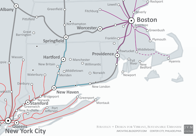 |
| Today: Intercity and Commuter Rail (including CT's forthcoming projects) |
However, as Kip Bergstrom, Connecticut's Deputy Commissioner for Economic Development, has frequently pointed out, Connecticut's, especially Hartford's, opportunity is not necessarily in connecting New Haven to Springfield, but by transforming itself from being the edge of the New York or Boston metropolitan areas to their center. He says passenger rail (probably an intermediate between commuter and intercity) is the tool to make this happen, which is why it's so important that the New Haven - Springfield route is being upgraded and service is being restored. Unfortunately, today and as currently planned, the vast majority of southbound trains terminate at New Haven and require a connection to MetroNorth or Amtrak (of which there are several options), and other than one Amtrak train to Vermont, northbound trains not terminating in Hartford (five of them will) will terminate in Springfield, with no meaningful connections to Boston.
 |
| from NEC Future (preliminary alternative 14) |
A prudent and achievable approach, which ConnDOT mentions in general as part of a broader vision, would be to focus on connections between central New England and Boston, be restoring service to what was known as the "Inland Route." Despite usually requiring connections at New Haven (a one-seat ride would certainly be preferred), there are countless southbound options to New York, and other than some possible MetroNorth extensions to Hartford or Springfield, additional service won't be feasible until additional track space is somehow created south of New Haven.
At the very least, New Haven-Hartford-Springfield service should become New Haven-Hartford-Springfield-Worcester Service. There are seventeen recently added daily MBTA trains from Worcester to Boston (which have been a huge boon to the city of Worcester), any number of which could be integrated into this expanded Inland Route service. Even if full New Haven-Hartford-Springfield-Worcester-Boston service isn't possible due to track or schedule capacity, the connection options are still available at Worcester.
 |
| Possible Improvements: Berkshire Service to Fairfield County and NYC; Revival of the Inland Route between New Haven and Boston |
If Massachusetts needs Connecticut's help to restore Housatonic service from New York City and Danbury to the Berkshires, Massachusetts ought to do its part for Connecticut by helping restore real service between Springfield and Worcester. Northwestern CT communities like New Milford and North Canaan would certainly benefit from the former, and Springfield would absolutely benefit from the latter, not to mention all those Bostonians looking to get to its new casino or make use of increased access to points south. This will require the Commonwealth - and quite possibly the Congress - to work with CSX, the owner of the Boston-Springfield rail, but the fate of central New England depends on it.
In 1999, Amtrak upgraded infrastructure (electrification between New Haven and Boston, along the coast) and introduced Acela service. As a result, speeds increased and service jumped from eleven to nineteen daily trains (based on Amtrak timetables) in each direction between Boston and New Haven; this improvement led to a 45% increase in ridership in 2000 (revenue up by 77%), alone. The City became better integrated with the rest of the Northeast Corridor and has certainly continued to reap the benefits. This phenomenon can happen for the Central New England cities of the Inland Route, and be repeated in Boston with restoration of continuous service along New Haven-Hartford-Springfield-Worcester-Boston.
Cities with good passenger rail service will attract people and reap the economic benefits, and those without will likely not. But in a dense region of small jurisdictions like New England which is often slow to change, such service will require consensus and hand-in-hand collaboration, with a touch of impatience, of the of all elected, appointed, and private sector leadership.